Day 75-76: Give Me Puppies and I Never Leave

Saturday, July 2:

With my hip less then sub par, a weekend rave I wanted to avoid, and plenty of days before I needed to meet my dad in Belden (only 18 mile away), I decided to take a full zero at Buck’s Lake.

Started off with an amazing breakfast. Keep feeding me like that and I’ll never leave! The day was filled with a couple games of Farkle, lunch at the Lodge, break in the hammock, and live National Geographic…who needs tv when you can watch a red tail hawk eat a sparrow right in front of you!

It was a good day to stick around. Not only to rest my hip, but to also baby my blister which was on the verge of infection. Last but not least, I reunited with a familiar face that I hadn’t seen since Idyllwild, Shay! We leap frogged from Warner Springs to Idyllwild and shared campsite and company through the section. He was a lot tanner, but still the kind and humorous Shay I remembered. It was good to catch up and hear some of his stories.

A few more dogs (and people) joined the party as well. The count was up to seven!

Feed me tri-tip and fruit, provide a plethora of puppies: I may never leave!


Sunday, July 3:

My hip was no better, and I still had more then enough time to get to Belden. Today was also the day of the infamous Buck’s Lake Boat Parade and I heard a rumor about giant Smores – of course I had to stay another day!


Day 74: Right Place, Right Time

Day 74 (Friday, July 1): Bear Creek (mi 1250.3) to Buck’s Lake @ Big Creek Road (mi 1260.99), 10.46 miles + some road walking. (up/down: +3424/-1163ft)

Today was the day I’d been dreading. I tried to procrastinate leaving camp, but also knew I needed to start early to avoid the great. I hit trail at about 6:20 and definitely was in no rush to get to the top. I was going to go slow, take my time, and rest my hip. I ended up taking a quick sit break every 400 ft elevation gain or about 30 minutes. The breaks were fairly short as mosquitoes were quick to fester (Deet did help). Breaks were slightly longer when I’d reach a spring.

A couple people passed me on the climb, but I again didn’t see too many people surprisingly. I got to Lookout Spring, which was just about the top, at about 11:15 and took a nice hour long break to eat my second breakfast, postponing the more walking and the final ascent (at least for a couple miles). The whole morning, I also pondered what I would do when I got to Big Creek Road – a paved road leading to Quincy (town about 18 miles away with a huge music festival this weekend) or a Buck’s Lake (minimal “town” 3 miles away).

20160701_122113.jpg

I passed some great views before the trail lead into the trees where they appeared to be logging. This jaunt was less than exciting or beautiful. Then I saw the road and stepped foot on the pavement around 1:20. I opted to get off trail and recoup my hip for a day, and started walking towards Buck’s Lake. Thankfully, about 2 minutes into my exposed and hot road walk a truck pulled over and gave me a ride. He dropped me off at the local campground, which happened to be completely full. There was another campground about 3 miles down the road, but I had no intention of walking there in the afternoon heat, let alone at all.

20160701_170218.jpg
I’m a happy hiker!

I walked to the Buck’s Lake Lodge to enjoy a free beer and some lunch while I decided what to do. I got lucky during lunch: I ordered a salad instead of fries, but the cook still made fried instead so I got fries AND salad! Also, a wonderful family offered to take me in. I can’t say much per request – but it was definitely a highlighted experience of the whole trip and in consequence days, you’ll find out. Also – DOGS! I was so relieved to not be hiking and enjoying some fresh fruit, recoup and company.


I know I said DOGS, but did I also mention BIRDS of PREY?!

That night I went back to the lodge for a short bit to check my email and other internet things. I was so delighted to see a handful of posts from my Ruff Trail supporters 🙂

fb_img_1467432239807.jpg

Day 73: The Marathon

Day 73 (Thursday, June 30): Bear Trap Creek (mi 1224.12) to Bear Creek (mi 1250.53), 26. 41 miles! (up/down: 4785/-7500ft)

I left camp around 6:20a just after Perma-smile and Rafiki, fairly certain I wouldn’t see them again as they were cruising and crushing big miles. A few steps out of camp, I felt a sharp pain in my hip/groin. Crap, I strained a muscle. This was going to be a long day.


After having plentiful water the past few days, today was a bit different, though still nothing like the desert. There was a “lake” named Duck Soup Pond a third of a mile off trail in about 3 miles. By the time I got to the road that lead to the pond, it was incredibly buggy. And the view I had of the pond from trail showed why the pond had such a name….It definitely did not appear to be worth the extra walk. I’d suggest anyone only go there in an emergency situation. There was another trail just after the road that leads to a spring that I’m betting was a bit cleaner. With no reliable update of the spring from the water report (one downside of being ahead of the heard), the extra walk, and atrocious amount of mosquitos I decided to wait it out until the next water.


About 3 miles later, I reached Quincy La Porte Road where there was a strong creek about a third of a mile down the road. I pulled over on the side of the road trying to figure out exactly where the PCT continued as signage want great at the intersection. I also tried to decide if the water was worth the hot walk down the asphalt with a climb back up to the trail, with more bugs. I still had some water, and decided to push on again. I wanted to eliminate as much up hill walking as possible as it really hurt my hip.

20160630_163614.jpg
Grateful for shade

After 5 hours and 10+ miles from camp and my last refill, I reached the junction to Alder Spring. I was going to drop my pack on trail and walk DOWN a 1/4 mile to the spring. But that would require another walk back up. The trail to the spring would pass a road about halfway. The PCT also would cross this road about a half mile down. So instead I brought my pack down the trail to the paved road and continued another 400 steep feet down to the delicious and cold spring. Even just the short climb back to the road sucked. Though here I’d take my first full fledged, pack off, sitting break. I enjoyed a second breakfast, charged my electronics, and found the perfect spot to roll out my muscles.


The next part of the afternoon was mostly down, which was a relief but still beating me. Around 3:20 I got to the trail junction for Fowler Creek. The sign read 500 ft to the creek…but it was 500 ft pretty much straight down and straight up on the way back. The worse. After making it back to the trail and my pack, I quickly at my lunch/snack, because the bugs were also hungry for my blood and sweat.

20160630_123459.jpg
You had one job…

I somehow managed to get a second wind that carried me to the next two dirt roads. I begged for there to be someone on this desolate road that could give me a ride. I was now wishing I stopped one of the few cars that passed me on the road near Alder Spring. No luck. I continued walking and losing a ton of elevation until I got to the Middle Fork River (the decent down was great, but just reminded me of the huge climb up I’d have tomorrow). It was 5:30 by the time I got to the river – I stopped for a water refill and a short break. I wish it would have been earlier with some company as it would have been so refreshing to go for a swim. All I wanted at this point was to get to camp, which was about 1.5 miles up 780 ft of ascent.


The climb was slow going and rough. I could hear the stream flowing not far in the distance where the campsite would be, and was relieved. That is until I got to the stream…There was no campsite, only steep drop-offs. F#@k The trail guides were wrong. I worried how far it would be to the next site as I now didn’t trust what my guides and map described. 2 miles later, I passed the wooden bridge that was earlier described over the real Bear Creek and came to a campsite around 7:40p. Excuse my language, but Holy Shit…I just did my first actual marathon day! I’d done 26 miles before, but not all on trail (incl. walking around camp and side trails to water). Today I walked 26.41 PCT miles, plus close to another mile or more on side trails. Damn.


26+ miles come with a cost…

I somehow managed to catch up with Perma smile and Rafiki who were at the same site. I set up camp, but had no appetite for dinner. I forced my self to snack and then crashed not looking forward to the 3500 climb in the morning.

20160630_174131.jpg
Middle Fork River

Day 72: No Food for You

Sorry for the delay. I actually had this whole post written, but then my phone deleted it. I was pissed and it took me a while to gain the motivation to re-write it.

20160629_114652.jpg

Day 72 (Wednesday, June 29): Packer Lake Trailhead (mi 1204.9) to W Branch Bear Trap Creek (mi 1224.12), 19.24 miles. (up/down: 3098/-4163ft)

I was up early to ensure I didn’t miss my generous ride. I packed up and headed to the porch of the store to finish up charging. My ride arrived promptly at 6:30 and we headed up the hill. He verified that I wanted to be dropped off at the lodge instead of the trailhead. After missing out on Red Moose Cafe, I knew I wanted some Packer Lake Lodge breakfast. I was near certain I’d be able to find a ride from another guest at breakfast as well. If not for some reason, the trailhead was only 3 miles up a steep road (still better than 9 miles up a steep trail).

packer_lake_lodge_2008_lodge

I got dropped off at the lodge by 6:50, but it didn’t open until 8. So I nestled into the comfy chairs on the porch for some rest and watched the hummingbirds. Just before 8a, a worker came out on the porch to water the plants. Surprised to see me, she asked if I need anything. I replied, that I was just waiting for breakfast. I was in dismay to her response: there was no breakfast on Wednesdays. The menu in Sierra City did list that there was no meal service on Tuesdays, but said it served on Wednesday. I guess this had since changed. Shit. The worker was quite empathetic and said she could rummage through the kitchen and maybe make some eggs and toast. I said it was quite alright, and that I had food (though I had no intention of digging it out of my pack). Instead I asked if she knew of a way I could get to the trail. Her best suggestion was to just wait until the guests started to get up and venture out and ask if one of them could take me. The maid or maintenance worker may also be able to give me a ride when they arrived.

So, there I was, sitting on the porch – waiting. After some time a gentleman walked into the parking lot and I approached him. I asked where he was headed today. Him and his family were going to Sardine Lake for some fishing, and claimed he would have no room in his Prius for me. I really think he just had no interest in helping out. Back to the porch I went. Was this a sign to not continue? I was tempted to use the pay phone to call my dad, but didn’t have enough quarters. Was this a sign to keep trying? A few minutes later, a couple visiting from Sacramento walked into the parking lot, heading toward the lodge. I met them half way. They too were coming up for breakfast and also disappointing to hear the news. I shared with them my predicament and they immediately offered to make me some oatmeal and take me to the trail. I declined the food, but happily accepted the ride.

This slideshow requires JavaScript.

I started back up at the trailhead (mile 1204.9) at 8:35a, skipping the 3000+ ft hot, exposed, and steep climb out of Sierra City. From here I saw amazing vistas, forests, and lakes in full 360 degree views. Being from MN, it was so nice to see “so many” lakes after coming from the dry desert of both UT and SoCal. For majority of the day, I saw no other people except early afternoon when I ran into a group of day hikers in the opposite direction and a SOBO hiker after lunch.

I was glad to be descending during the hottest part of the day. Though, not too much later, I went back to climbing. I had a nice little laugh and neature moment when I ran into a deer on trail. She was munching and really didn’t want to leave her munch spot. I waited. She didn’t move. So I kept slowly walking toward her. Still no movement. She then finally decided to walk ahead too, but not far. I followed close behind her for at least a quarter mile. A mid the climb, some hikers I had left in Sierra City caught up to me.

20160629_161203.jpg20160629_161248.jpg20160629_161252.jpg

I closely followed behind them the rest of the evening as we dropped quite a bit of elevation. My goal was to make it to Bear Trap Creek, which I did and then continued further to another branch. I camped with Perma-smile and Rafiki. A friendly deer also joined us for more of the night, stalking us, and not afraid of Rafiki’s attempts at conversation with him. As I was settling in for bed, I heard a rustling of sticks and leaves crunching outside. I assumed it was still the deer, but I peeked anyway. I saw some movement in a tree. A black figure that looked to be a racoon or something. But then I saw mama bear! It was a little baby black bear cub practicing his tree climbing with his mom telling him to hurry up from the ground, about 30 ft from our camp. Cool! We stayed very quiet and they scampered off in the opposite direction.

20160629_193604.jpg

Each day is made up of a million small goals. I may have an idea where I want to get but I really just look at the day a few steps at a time. Shade to shade. Water to water. Hill to hill.


Day 71: Oh Deer

Day 71 (Tuesday, June 28): mi 1174.94 to Haypress Creek Side Trail (mi 1192.93) + 3.5 miles to Sierra City, 21.49 miles. (up/down: +1712/-4766ft)
So I’m pretty sure the deer hung out and wandered around our camp a while last night. I also fell asleep before I put in my earplugs and midnight I heard the weirdest shrieking noise – one I’ve never heard of before.

We packed up and left camp around 6:37a. Since we were dry camping, we opted to skip breakfast until we got to the creek. There were mediocre climbs, made much better with the cooler morning air, vast views, and a partner to motivate me. Thanks Annette! About 2 hours later we got to Mule Ears Creek for a nice hour-long break and breakfast.

20160628_073930.jpg20160628_074742.jpg

20160628_092752.jpg

After breakfast, we went through some more rolling hills. We were keeping an eye out for Jackson Reservoir as that was where Annette was going to stay for a day or two. We kept seeing lakes and assumed that was the reservoir. We were always wrong until we knew for certain we were right. It was a big beautiful lake. Soon after views of the reservoir, we dipped down to eventually meet a road. This is where we would separate – I’d continue on towards Sierra City and she would take a rest day at the lake and campground. I must say, I was so glad to have had a partner to journey with the last day and a half. That snow would have been even physically rougher and mentally tougher alone. I was happy to have a second set of eyes, a photographer, and a conversation to distract me when the hiking wasn’t best (i.e. climbs). We said our goodbyes and headed separate ways.

20160628_105919.jpg20160628_111639.jpg

Of course, the trail went back up in the heat of the afternoon. I struggled some, but continued to push on and was hopeful as Sierra City was less than a day away. I finally reached a high point for the day and started back down. Wow, the way down would have been awful for anyone going up. Steep, rocky, and exposed. Yuck!

20160628_124035.jpg

20160628_131720.jpg
Top of the rocky descent

I stopped for lunch at Milton Creek at about 2:15. It was a beautiful shaded spot with a nice little seat. I had planned on stopping just short of town at Wild Plum Campground…if it weren’t so early Milton would be a splendid place to camp.

20160628_141607.jpg
Ahhh the little things

20160628_153932.jpg

20160628_140222.jpg
Shade!

It was an intensely hot afternoon once out of the shade. I took the alternate road walk through Wild Plum to get to town and it was hot and exposed. It was still plenty early when I got to the campground and I pushed through the heat to get to Sierra City around 4:30 where I could camp at the church for free.

I was around people again! Though per usual stayed to myself mostly. I hung out on the store porch using the Wi-Fi and sorting my resupply for the next stretch to Belden in the company of Perma-smile and Rafiki. I contemplated how I’d get up the long steep stretch up (3000+ ft climb) the Butte in the morning. There was a trailhead about 8 or 9 miles up near Packer Lake. The store owner said there was a senior shuttle that might be able to give a ride, but I had no luck getting a hold of them. I took a quick shower, surprised by the ice cold water. Nonetheless still very refreshing!

20160628_183948.jpg

Some time later, I asked another store worker if she knew of someone who might be headed up that way in the morning. A friend of hers worked at the Lodge on the Lake but she also couldn’t get a hold of her. Sometime later she found me and said her husband could take me early in the morning on his way to work. This would mean I’d have to miss breakfast at the Red Moose Cafe and get up early, but it was a guaranteed ride at 6:30 a. I saw a sign at the store with a menu for Packer Lake Lodge that looks like it had some good options. I decided I’d take the ride and stop at the Lodge (which was 3 miles from the TH) for breakfast instead.

Relieved that I’d get to bypass the climb, I relaxed for the remainder of the evening. The store was closing and they brought out some refreshing complimentary passion fruit ice tea..yum! I also ran into Druid again who I originally met in the desert. I finished up using Wi-Fi and charging my electronics and headed to bed.

Day 70: Getting through Hurdles

​Day 70 (Monday, June 27): Peter Grubb Cabin (mi 1160.76) to mi 1174.94, 14.18 miles. (up/down: +2349/-2383ft)

I woke up at my usual 5:30, but everyone else was still asleep so I tried to sleep in a bit longer. I didn’t have much luck and eventually quietly and slowly started my morning routine. The others soon followed suite. I got a bit of a later start around 7:20 which I wasn’t too worried about as I wasn’t planning on getting in a ton of miles.

Annette planned on doing the 35 mile section to Sierra City in 5 days while I was planning 2. Mr. E warned us that today would be frustrating as we’d be doing some bush whacking, navigating and snow crossings. Annette and I were glad to have each other – 2 sets of eyes are better than 1!

Mr. E was right, today was tricky. At times we just made our own trail to get around snowed in switchbacks, mud and streams. I fell twice – once on my bum down the snow (guess I should have just glissaded) and another time face first in the gravel. Annette mentioned that if she had been solo she would have probably turned around. I am honestly not sure what I would have done if I were alone. Along with help getting through sketchy sections, it was also nice to have some conversation, motivation, and a photographer. The day provided amazing views of the mountains, lakes and wildflowers.
We had made it about 14 miles by 5. My goal was to make it at least this far and then see how I feel. There were some more sites in a couple miles, and I could have continued. Though Annette had planned on only going about 7 each day if solo, and we both would rather camp with someone else – I knew I would be bored sitting around camp, so I said as long as we’d play cards I would stay.

We had not seen anyone else all day. We made bets on how many we’d see that night. I guessed 2 and within 30 minutes 6 finally passed us. After dinner, we gathered in her tent to escape the horrible mosquitos and to play Egyptian Ratscrew. While playing, we got a guest. A lone deer wandered around our site. We stayed silent, though still making slight noises. The deer got very close and kept staring directly at us, though it appeared that she couldn’t actually see us through the mesh. She came and went throughout the rest of the night.

Ate:

Granola and milk

Rise Bar

Pepperoni and Cheese

Protein Drink

Dried Fruit

Honey lime chicken

Snickers

Day 69: Town to Trail

Day 69 (Sunday, June 26): South Lake Tahoe Event, I 80 (mi 1157.25) to Peter Grubb Cabin (1160.76), 3.52 miles. (up/down: +874/-292ft)

This morning was a fight as I tried to figure out how exactly to structure my day; attending the event in a Tahoe, then if and where to start hiking again.

I was concerned about snow and trail conditions. Ranger stations/offices were closed for the weekend so I wasn’t able to get an up to date report. I ended up calling the Sierra Country Store and they gave me a relieving report which boosted my morale.

Zeek
Zeek

I packed up and headed towards South Lake Tahoe for the Bark in the Park Event with the Lake Tahoe Humane Society. After initially getting a little lost when the GPS took us to the long location, we made it to the park. It was a last minute event, but I’d still call it quite successful. I met some more great and supportive people and puppies!  Nikki with the Humane Society was so nice and helpful and offered to sell my bandanas throughout their events for the summer. I got a lot of face licks from Zeek of the El Dorado Animal Services, live music, hot dogs and a K9 Demo. Nikki talked about their awesome event coming up in on July with a celebrity scavenger hunt, paddle and camp out. I wish I could be around for it!

wp-image-1355165102jpg.jpg

We left a bit early so we could get through the traffic and to Truckee before it got to late. With all the last minute changes (of when and where to start the trail up again), I needed to get a resupply package to Sierra City for my arrival in about 2 days – but the postal service wouldn’t get it there quick enough. I was going to have my dad take a detour and drop it off in his way home. At this time it was mid afternoon and nearly 90 degrees, and I did not want to hike in this heat, so instead we took a side trip to the Sierra Country Store to drop off my package.
It was time to suck it up and start hiking again. That moment is always the hardest, whether taking a day or a week off. Once moving again it’s not so bad. I left the I 80 rest stop at 6:15, still warm but not blazing hot. My dad and step mom took the side trail to the PCT with me and we said our goodbyes and I was alone again. A short time later the highway noise dissipated and I was truly alone.

How did that get up there?

The first mile was great and I was feeling positive…then I sunk and my momentum became sluggish. At about 7:45 I made it to the Sierra Club Cabin. I scouted the area and found another tent-happy to see another person! As soon as I started to set up the hiker said that I may not want to stay there as she was a smoker. I said I didn’t mind, but knew it was her way of nicely saying get away. I spent some more time looking around for another area, which I found but kept looking as I assume there had to be more people around.

I thought the Peter Grubb Cabin was just like the Meiss Cabin, just a monument. To my surprise, I saw movement in the top of the cabin-people! There were two guys and a gal, and I opted to stay in there as well. The downstairs had tables, stove and a “kitchen”, while the upstairs was an empty loft. Mr. E was finishing a section southbound that he skipped the year before. Scott was just out for the weekend headed back to Truckee. Then there was Annette who was doing a short section to Sierra City Nobo. I immediately asked if she was looking for a partner and we both rejoiced! I wouldn’t be alone at least for a day! Woohoo.

wp-image-1786463900jpg.jpg

Day 63-68: Hitting a Wall

Day 63 (Monday, June 20): Bus to Bishop, Drive to Carson Pass. Carson Pass (1076.79) to Showers Lake (1081.93), 5.14 miles. (up/down: +740/-647)
image

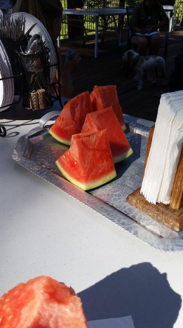
I left the Lone Pine on the bus to Bishop at 8:30. I spent a couple hours in Bishop running errands and spending more money than intended. I am so lucky that my family in CA is caring enough to help me out when needed. I met up with m Aunt and Uncle just before 2 for some lunch at Schat’s. A mighty good sandwich, big enough for two meals! From there we headed north where they would drop me off south of South Lake Tahoe. I originally planned to start back up at Ebbits Pass on Hwy 4, but they talked me into Hwy 88 at Carson Pass. In the turn of events that were about to conspire over the next 24 hours – I am so glad that the did!

After a 3-4 hour car ride, we arrived to Carson Pass and I hit trail again at 6:20. I hoped to make it in about 3 miles to Meiss Cabin. With all these hiccups occurring and being in civilization, the trail continues to get harder to return to. Again I thought, it would be so easy for me to just ride home with them. My motivation continued to dwindle – but I walked.
image
image

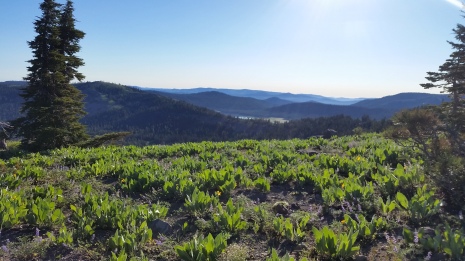
I made it to Meiss Cabin, but it was still plenty early. It was also the first day of summer, which technically means that it was supposed to be the longest day (in the end it felt no different). There was also no good tenting spot at the cabin, so I decided to push on to the lake – I wouldn’t have to spend time making dinner either as I had my sandwich for leftovers. I am glad I did, as I was rewarded with fantastic views towards the lake and of the surrounding sky and mountains. Despite my first actual creek crossing and wet feet for the duration of the evening, my motivation bumped back up a little.
image

image

image

image

It was turning to dusk in the valley. As the sun started to disappear behind the hills, so did the trail in the snow. Thankfully, it was very short sections of snow patches that were easy to navigate. However, when I made it to the lake – I was a bit lost. The trail vanished into the snow, and footprints went both directions around the lake. I turned to my gps to see the map – but turned out to be little help. It showed the trail on both sides! The view with the sunset was amazing, and I was settled on the idea just to camp where I was standing. Not a minute later I saw a light! It was a headlamp! There were others here, I wasn’t alone, and they must be at the campsite. I followed the light and hopped back on the trail to find my own campsite right next to the stream/waterfall leaving the lake. I made it to camp at about 8:35, and enjoyed my sandwich for the second time.
image

image

Day 64 (Tuesday, June 21): Showers Lake to …. 1.82 miles x 2 + 5.14 = 8.78 miles

I let myself sleep in a little as I intended for a “short” 15 mile day to Aloha Lakes. Before suiting up my pack, I tried to find the trail. I was camped right next to the stream leaving the lake that was flowing heavily. On both sides were walls of snow following the cliffs. Apparently, that’s where the trail was. I spent nearly an hour wandering around hoping my neighbors (3 friends just base camping for a couple days) would wake up so I could ask them if they knew where the trail was. They apparently were sleeping in too. I finally found the trail on the other side after some rock hopping and stream crossings. I returned to my pack and set off.

Two hours later, I managed to have gone 2 miles. The trail followed a steep snow covered hillside full of sun cups. From there, it was a crap shoot as to where the trail went. I had cell service and called my dad who is 2 hours away. I told him my circumstance and told him I’d keep him updated as I may not make it through. I was thankful to have my GPS to help navigate and trail find, however it could only help so much…The trail would disappear into the feet of snow, then reappear 100 ft later and 60 feet higher. If I wasn’t hiking in snow, I was hiking in puddles and creeks. As I got higher, the snow got deeper and the trail harder to find. More trees surrounded me, and the few footprints i was following pittered out. The forest was getting more dense, making the navigation even harder. I had re-evaluated earlier, and settled on hiking into South Lake Tahoe versus Aloha Lakes. I was about 6 miles away, but could not find my way. I saw a trail marker in the snow melt and got so excited. Maybe I could make it…Nope. 10 feet later the trail was gone. I made it to mi 1083.75.
image

image

image

image

image

image

My mental state was being battered. Just yesterday I went through the roller coaster of wanting to quit (first days back after a break are the hardest), but gratefully deciding to continue. Now that I was ready and excited to go on, the trail seemed to be fighting me and wanting me to quit. I had to make another judgement call. I could not safely or enjoyably navigate my way down the North side of this snow covered ridge alone, I had to turn around.
image

As soon as I turned around and started back towards Shower’s Lake, I started balling.

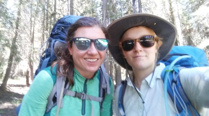
I took a break back at Showers Lake to rest and recollect my tattered emotions. On my way back, I ran into a crew of 4 PCT hikers who were heading north. I told them about my struggle, but told them I was confident they could handle it – I just couldn’t solo. They offered to go through with me, but I beat both physically and emotionally and didn’t want to do the same thing all over again.

image

image

image

image

My legs were beat from the snow hiking from the morning, and my emotions were exhausted making the final trek back to Carson Pass a difficult one. I finally made it back at 1:40. I spent a couple hours resting, and chatting with the Visitor Center volunteers and a day hiker, Nancy,  waiting for her husband, Bob. They were a couple from Michigan (she even taught in Duluth) who come out yearly for some day hikes. Nancy and Bob gave me a ride into South Lake Tahoe to the Lake of the Sky Outfitters after getting some delicious smoothies.
image

At LOTS I ran into the same hikers I had crossed paths with earlier – they had made it through just fine – go figure. I spent some time here getting a game plan. My dad would meet me tomorrow and I would go back with him to Grass Valley until my event in South Lake Tahoe with the Humane Society on Sunday. In the meantime, I took the bus across town to Dog Dog Cat, a company sponsoring me, to introduce myself! From there, I went to a trail angel’s house for the night – Thanks Lauren and Prince (the cat)!

Day 65-68 (Wednesday, June 22 – Saturday, June 25):

My body and mind are beat. I am deficient of so many nutrients and brainpower. The first couple of days have been hard, barely able to make it up the backyard. I need protein, sleep, and an emotional boost. After a couple days and lots of healthy food later, I a feeling slightly better but still sluggish and strained up hills. I will be heading back to Tahoe tomorrow (Sunday) for my event with the Humane Society and will be getting back on trail. I am becoming more and more flexible. In just the time I was repacking my food bag and upcoming resupplies, my plan changed 3 times…. I hope all goes well from here. Wish me luck, little snow, and a hiking partner!


Day 62-63: Hung Over the Edge

Day 62 (Saturday, June 18): Diaz Creek (741.65) to Horseshoe Meadow Campground via Mulkey Pass (744.51), (2.86+1.7) 4.56 miles. (up/down: +850/-667)

I made it through the night. The Diamox made me have to pee like a race horse though – getting up 3 times in the night. It was still hard to do anything this morning. My brain still felt like it was going to explode and it was hard to move (both from being weak and lightheaded). I wasn’t hungry but knew I had to consume something, so I brewed up some coca tea and had some fruit snacks. I ever so slowly packed up camp as I saw Honey was still in her tent and neither of us were in a huge hurry.
image

Today’s climb was the slowest yet. I thought my legs were going to give out and/or I would just fall over and pass out. We (Honey and I) were barely making a 1.75 miles an hour, but boy was I glad to have someone with me. As we got higher and further, we stopped for breaks more frequently. Many hikers passed us, one was going just about as slow as us. Roscoe – we liked him! Finally, we made it to the first pass that would lead us into Lone Pine just before 10 am.

image

Hooray! But it wasn’t over. We still had about 2 miles to the campground with no guarantee of a hitch. Thankfully the hike was all downhill to the beautiful meadow providing vast views of the Sierra Mountains (including Whitney), streams and wildlife. We got down to the stream in the meadow and took a short break on a rock enjoying the views and envying the last uphill climb, even though it was maybe only 60-75 ft.
image
image

We had made it to the Campground!…Well the road to the campground. The closest facilities were about a quarter-mile up. I was still feeling like shit and instantly dropped my pack on the side of the road. Roscoe and Honey thought about walking down the road East towards Lone Pine. I sat and didn’t move and convinced them that this was the only road up or down. If we walk down, anyone leaving might pick up hikers behind us first. So we stayed where the trail met the road. Honey and I took the short but excruciating walk (felt like the worse possible hangover) to the bathrooms and water. We thought we say trail magic, but just turned out to be a group hanging out for the day – bummer. There were a lot of folks out day-hiking, and we knew we’d be able to get a ride from someone when they finished – but that could be hours from now.

1-08
Road to Horseshoe Meadows

We walked back to our packs, which sat just behind the sign marking Bear Country. Now that we were not moving and there was a slight breeze, we felt a bit chilled and laid on the pavement..ooh that felt nice. Within moments we were blocking a white SUV heading out. They probably would have stopped regardless, but they offered us a ride! They had just dropped off their kids and picked up another hiker on the way down with just enough room left for the 3 of us and our packs. The ride down to Lone Pine was INSANE! I knew we were up pretty high, but when you’re in it (the mountains) there is really no reference point as the valleys are still very high. As soon as we come over the ridge, holy shit, we were high! It was like coming over a roller coaster, only multiply the drop by 100. After a long drive down full of switchbacks, and thankfully my fruit snacks and quarter of a Bobo’s bar stayed in my stomach, we pulled into Lone Pine.

The first stop was the Whitney Portal Hostel where I would spend the next night or two. My brain and body were still very foggy but could feel a very minor improvement. Honey and I got cleaned up and headed over to Alabama Hills Cafe for lunch and to do laundry next door. Delicious! If I had the money, I would have gone 3 times in a row like Honey over the next day and a half, but I had to save my change. At least I had enough leftovers to last me until lunch the next day.
image

Over the next day and a half, I am pretty sure I walked the length of Lone Pine at least 20 times in 100 degree hat. That is not hard to do when the main part of town stretches only half a mile. After the first day, I was feeling much better! The first night in the hostel was with Honey, Anmie (who I met in KM), a dad and 16 year old son, and a young guy. A good group who shared lots of goodies (whiskey, muddy buddies, chips and guac), laughs and solid conversation. Silence and lights out by 9pm. On Sunday, I tried to walk 2.5 miles along the highway to the visitor’s center. I got halfway, said screw it, and turned around – at least I got some steps and sweat in. The second night was not as peaceful. A new group of hikers came to stay – these one’s enjoyed to party. Finally, by about 10 we made them turn the light off.

The PCT is constantly testing you…this was my first big test. I had to make a judgment call for my well-being. Tomorrow I would take the bus to Bishop and meet my aunt and uncle who would bounce me up the trail. There was no way I could go back up 10,000 ft. Whitney would have to wait.


Day 61: Highs and Lows

Day 61 (Friday, June 17): mi 720.4 to Diaz Creek (741.65), 21.25 miles. (up/down: +3907/-3235 ft).

I woke up to find a strange thing that had happened to my bear can. It had not been moved, but there were a decent-sized dent and scuff on the top of it. There were no scratches like you’d expect from an animal. It almost appeared like a rock fell on it, but nothing was in sight. A mystery!
image

I packed up and left camp by 6:45, continuing up to find Cow Creek – not knowing if I would find more water or not. Thankfully there was still salvageable water that would get me up and over the mountain in front of me. It was a slow struggle as I climbed, but provided beautiful views of the valley below. I leapfrogged shortly with another hiker who was also struggling with the thin air; others whizzed by. Finally, I reached the top and could see far far away to the snow mountains ahead. From here it was a nice descent down to water! I took a short break, did some blister first aid, and filled up on enough ice cold water to get me 3 “flat” miles to another water source.
image
image

I arrived to Death Canyon Creek which surprisingly had a beautiful flow and many others were also taking their lunch break here. After about an hour I decided to make way. There were 10 miles until the next water source and I was considering dry camping at a spring 5 miles away to make for an easier 5 mile day as I was exhausted from the elevation.
image

image

image

I made my way up to nearly 11000 ft going less than 2 mph, painfully slow. My pack was nearly just as heavy as it was when I left Kennedy Meadows as my appetite has been depressed since getting into such high altitude. I took a short break near Owen’s Peak where there was full cell service along with a crazy view toward Lone Pine – we could see how high up we really were. I had made myself eat a full meal at lunch and was starting to feel quite sick – nauseous, weak, light-headed. I could barely continue and finally made it to my goal of 15 miles at the dry spring. Well, I made it to the junction and had no intention of walking the 1/3 mile to check the accuracy of the water report.

image

image

I was still feeling awful and like my head was going to explode. I was at 10400 ft and knew I had to get as low as possible and that I would have to push on another 5.5 miles to Diaz Creek and campsites that were almost 1000 ft lower. I cried on my way down. Well, my body tried to cry, but I held back as I could barely breathe as is. I was still nauseous, short of breath, weak, could feel my brain expanding and could not walk in a straight line (well less than usual). I was not cut out for the Sierra – at least not now. Strange too, as I was just fine when I went to over 13000 ft in Peru. I think one big problem was how quickly I pushed myself out of KM. I decided that tomorrow I would go down into Lone Pine and re-evaluate. I was just hoping I could get there without any major problems or need for rescue.

I finally arrived to Diaz Creek and found Honey! I was so happy to see someone I knew and could rely on. I dumped my stuff and started to set up camp. I could barely stand. I confided to Honey that I was in bad shape and she so graciously offered me some of her Diamox (altitude pills). Shortly after, I headed down to the creek to get water. I didn’t make it very far before I had to pull over behind a tree to throw up. Everything I had eaten that day and drank with in the last few hours came up. Shit – I hoped I could get out tomorrow okay. I continued down to get water and barely made it back to my tent with my head in a fog. I returned to Honey and asked if she would walk out tomorrow with me.